The Oneonta Gorge is in the Columbia River Gorge in the American state of Oregon. The U.S. Forest Service has designated it as a botanical area because of the unique aquatic and woodland plants that grow there. The basalt walls are home to a wide variety of ferns, mosses, hepatics and lichens, many of which grow only in the Columbia River Gorge. Oneonta Creek runs through the gorge. There are four major waterfalls on the creek. Middle Oneonta Falls can be seen clearly from a footpath and is very often mistaken for the upper or lower falls. The lower gorge has been preserved as a natural habitat, so there is no boardwalk or footpath through it as such.
Thus, Lower Oneonta Falls can only be seen by walking upstream from the creek's outlet at the Historic Columbia River Highway. To get to a vantage point where the entire lower falls is visible can require wading through water that in some places can be chest-deep, depending on the season and the relative amount of snow-melt. The upper falls are about 1 mile upstream from the middle falls and require scrambling up the creek or climbing down a canyon wall to view. The fourth falls which is "Triple falls" can be seen from a vantage point on the upper trails in the canyon.
Angel Falls is a waterfall in Venezuela. It is the world's highest uninterrupted waterfall, with a height of 979 m and a plunge of 807 m. The waterfall drops over the edge of the Auyantepui mountain in the Canaima National Park, a UNESCO World Heritage site in the Gran Sabana region of Bolívar State. The height figure 979 m mostly consists of the main plunge but also includes about 400 m of sloped cascades and rapids below the drop and a 30-metre high plunge downstream of the talus rapids. The falls are on the Gauja River (alternatively known as the Kerep River or Kerepacupai), which flows into the Churun River, a tributary of the Carrao River.
Angel Falls is one of Venezuela's top tourist attractions, though a trip to the falls is a complicated affair. The falls are located in an isolated jungle. A flight from Puerto Ordaz or Ciudad Bolívar is required to reach Canaima camp, the starting point for river trips to the base of the falls. River trips generally take place from June to December, when the rivers are deep enough for the wooden curiaras used by the Pemon guides. During the dry season (December to March) there is less water seen than in the other months (This can be clearly seen in the photos of the falls above)
The Goðafoss is one of the most spectacular waterfalls in Iceland. It is located in the Mývatn district of North-Central Iceland at the beginning of the Sprengisandur highland road. The water of the river Skjálfandafljót falls from a height of 12 meters over a width of 30 meters. In the year 999 or 1000 the Lawspeaker Þorgeir Ljósvetningagoði made Christianity the official religion of Iceland. After his conversion it is said that upon returning from the Alþingi, Þorgeir threw his statues of the Norse gods into the waterfall. Þorgeir's story is preserved in Ari Þorgilsson's Íslendingabók. A window in the Cathedral of Akureyri (Akureyrarkirkja) illustrates this story. MS Goðafoss, an Icelandic ship named after the waterfall, was carrying both freight and passengers. It was sunk by a German U-Boat in World War II, resulting in great loss of lives.
Source: 500px.com/photo/18240563/goðafoss-iceland-by-james-appleton
Source: 500px.com/photo/10078943/godafoss-by-dennis-fischer
The Kiama Blowhole is a blowhole in the town of Kiama, New South Wales, Australia. It is the town's major tourist attraction. Under certain sea conditions, the blowhole can spray water up to 25 metres in the air, in quantities that thoroughly drench any bystanders. There is actually a second, less famous blowhole in Kiama, commonly referred to as the "Little Blowhole" by locals. It is much smaller than the other (called the "Big Blowhole"), but due to its narrow shape, it is actually more reliable than the Big Blowhole, and in the right conditions can be equally spectacular. The blowhole attracts 600,000 tourists a year. Kiama Blowhole is just a few metres beyond the coastline. The "little blowhole" is located at the Little Blowhole Reserve, Tingira Crescent, Kiama, a few minutes' drive south of the main blowhole.
Source: 500px.com/photo/14313225/boneyard-falls-redux-by-peter-hill
Skradinski buk is one of the most attractive parts of the park. It is a massive, clear, natural pool with high waterfalls at one end and cascades at the other, located in the Krka National Park in Croatia. It is the lowest of the three sets of waterfalls formed along the Krka river. In an area 400 m in length and 100 m in width there are 17 waterfalls and the total difference in height between the first and the last falls is 47.7 m. Due to the wealth and variety of geomorphological forms, vegetation, and the various effects caused by the play of light on the whirlpools, Skradinski buk is considered to be one of the most beautiful calcium carbonate waterfalls in Europe. The rate of flow is 43 m3 a second in winter, 18 m3 in summer, with an average of 55 cubic metres a second flowing down Skradinski buk annually. It is the largest travertine cascade system in Europe.
When you are at the Krka National Park there are several places of interest. The attractions and facilities available are various footpaths, sightseeing tours and presentations, boat trips, souvenir shops, a museum, and restaurants. There are also several archeological remains of unpreserved fortresses in the park's vicinity dating back to as far as the Roman times. They are Čučevo, Nečven, Bogočin, Ključica and Burnum.
Source: flickr.com/photos/rkroenert/10156092003/
Source: 500px.com/photo/4880600/krka-waterfall-by-dusan-milak
Source: flickr.com/photos/sergiu_bacioiu/4404273656/
Capitol Reef National Park is a United States National Park, in south-central Utah. It is 100 miles long but fairly narrow. The park, established in 1971, preserves 241,904 acres and is open all year, although May through September are the most popular months. Called "Wayne Wonderland" in the 1920s by local boosters Ephraim P. Pectol and Joseph S. Hickman, Capitol Reef National Park protects colorful canyons, ridges, buttes, and monoliths. About 75 mi of the long up-thrust called the Waterpocket Fold, a rugged spine extending from Thousand Lake Mountain to Lake Powell, is preserved within the park. "Capitol Reef" is the name of an especially rugged and spectacular segment of the Waterpocket Fold near the Fremont River. The area was named for a line of white domes and cliffs of Navajo Sandstone, each of which looks somewhat like the United States Capitol building, that run from the Fremont River to Pleasant Creek on the Waterpocket Fold. The local word reef referred to any rocky barrier to travel. Easy road access came with the construction in 1962 of State Route 24 through the Fremont River Canyon.


Source: flickr.com/photos/nwade615/3604733291/in/set-72157619404572016/
Hamilton Pool Preserve is a natural pool that was created when the dome of an underground river collapsed due to massive erosion thousands of years ago. The pool is located about 23 miles west of Austin, Texas off Highway 71. Since the 1960s, Hamilton Pool has been a popular summer swimming spot for Austin visitors and residents. Hamilton Pool Preserve consists of 232 acres of protected natural habitat featuring a jade green pool into which a 50-foot waterfall flows. The pool is surrounded by large slabs of limestone that rest by the water's edge; large stalactites grow from the ceiling high above. The ceiling and surrounding cliffs of the grotto are home to moss, maidenhair fern and cliff swallows. The Ashe juniper (cedar) uplands of the preserve are home to the endangered golden-cheeked warbler. The natural pool and creek are not chemically treated, so water quality is monitored regularly and swimming is occasionally restricted. Hamilton Pool is part of the Balcones Cayonlands Preserve and is a protected environment.


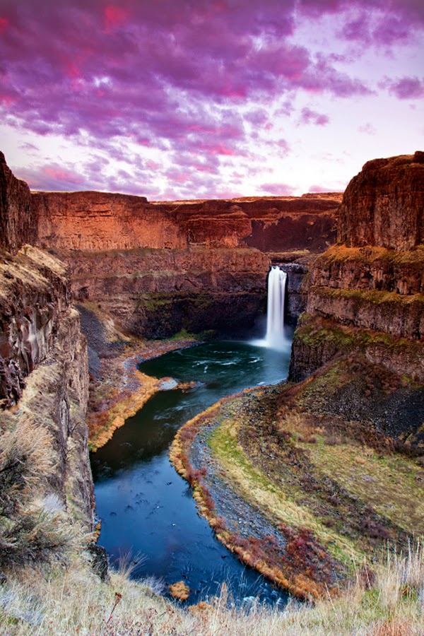
The Palouse Falls lies on the Palouse River, about 4 mi upstream of the confluence with the Snake River in southeast Washington, United States. The falls are 198 ft in height. The falls consists of an upper falls with a drop of ~20 feet which lies 1,000 feet north northwest of the main drop, and a lower falls, with a drop of ~180 feet. The falls are included in Washington State's Palouse Falls State Park, which provides access to the falls and has displays explaining the region's unique geology, as well as its historical ties (the Palouse Indians and the Mullan Road both took advantage of the easy access to the plateau in the vicinity of the falls).
Source: 500px.com/photo/9990571/palouse-falls-by-paul-james
Source: 500px.com/photo/39342650/palouse-falls-portrait-by-michael-brandt
Source: flickr.com/photos/craiggoodwin2/8542133679/in/photostream
Source: 500px.com/photo/11387003/palouse-by-s-amer
Umpqua National Forest, in southern Oregon's Cascade Range, covers an area of 983,129 acres in Douglas, Lane, and Jackson counties, and borders Crater Lake National Park. The four ranger districts for the Forest are the Cottage Grove, Diamond Lake, North Umpqua, and Tiller ranger districts. The Forest is managed by the United States Forest Service, headquartered in Roseburg. Stands of western hemlock, true fir, Douglas-fir and cedar transition to lower-elevation forests of mixed conifers and hardwoods. Timbered valleys of old-growth ponderosa and groves of oak separate mountains like the 9,182-foot Mount Thielsen and the 8,363-foot Mount Bailey. Notable geologic features include volcanic basalt and andesite monolithic spires with descriptive names like Eagle Rock, Rattlesnake Rock, and Old Man.
Umpqua Hot Springs is a geothermal pool located along the North Umpqua River at 2,640 feet elevation. Two oval pools are available for soaking, the larger having a solid rock bottom and the smaller a bottom of coarse sand. The larger is five by eight feet and 110 °F (43 °C), and is covered by a wooden enclosure. The upper pool is smaller but slightly warmer, measuring four by five feet and 112 °F (44 °C). Both pools are approximately two and a half feet deep. Umpqua is clothing optional.
Source: fineartamerica.com/featured/toketee-falls-jo-sheehan.html
Source: montetrumbull.com/stock/03-pacific-northwest/03-waterscapes/