The church is lovely, high above the beach. The beach is gorgeous white sand. Crystal clear water, Gentle surf - a sunbather's delight. Car park just nearby, or you can walk down from the town (but the return walk will test your stamina!). At the end of April, 2014 this site was closed to the public for ongoing work. It appears that the exterior of the church has been overly restored, inviting comparisons with a Lego building. Older photographs show a much more charming, slightly ruined building.
Tropea is a municipality located within the province of Vibo Valentia, in Calabria (southern Italy). The town is a famous bathing place, situated on a reef, in the gulf of St. Euphemia connected with the mainland by a narrow strip in the Tyrrhenian Sea, toward the south with respect to Vibo Valentia and northward with respect to Ricadi and Capo Vaticano.
Source: flickr.com/photos/bautisterias/6094240684/in/set-72157629633979817
Source: flickr.com/photos/bautisterias/6093962229/in/photostream
Shiprock is a census-designated place (CDP) in San Juan County, New Mexico, United States, on the Navajo reservation. The population was 8,156 at the 2000 census. It is part of the Farmington Metropolitan Statistical Area. Shiprock is named after the nearby Shiprock rock formation. It is home to the annual Northern Navajo Fair, held every October. Since 1984, the community has been the host of the Shiprock Marathon and Relay. It is also home to a campus of Diné College (formerly Navajo Community College), a tribally controlled community college with seven other campuses across the Navajo Nation. It is the site of a Chapter House for the Navajo, a Bureau of Indian Affairs agency, the Northern Navajo Medical Center (an Indian Health Service hospital), and a branch of Farmington Public Library. Shiprock is a key road junction for truck traffic and tourists visiting the Four Corners, Mesa Verde, Shiprock and the Grand Canyon. The town lies at the intersection of U.S. Highway 64 and U.S. Highway 491 (formerly U.S. Highway 924).

Source: fineartamerica.com/products/shiprock-inge-johnsson-poster.html
The Statue of Dacian king Decebalus is a 40-m high statue that is the tallest rock sculpture in Europe. It is located on the Danube's rocky bank, near the city of Orşova, Romania. It was commissioned by Romanian businessman and historian Iosif Constantin Drăgan and it took 10 years, from 1994 to 2004, for twelve sculptors to finish it. The final cost was over one million dollars. Under the face of Decebalus there is a Latin inscription which reads "DECEBALUS REX - DRAGAN FECIT" ("King Decebal - Made by Drăgan"). On the Serbian side facing Romania, there is an ancient memorial plaque (Tabula Traiana) commemorating the victories of the Roman Empire over the Dacian kingdom in 105.
The Oneonta Gorge is in the Columbia River Gorge in the American state of Oregon. The U.S. Forest Service has designated it as a botanical area because of the unique aquatic and woodland plants that grow there. The basalt walls are home to a wide variety of ferns, mosses, hepatics and lichens, many of which grow only in the Columbia River Gorge. Oneonta Creek runs through the gorge. There are four major waterfalls on the creek. Middle Oneonta Falls can be seen clearly from a footpath and is very often mistaken for the upper or lower falls. The lower gorge has been preserved as a natural habitat, so there is no boardwalk or footpath through it as such.
Thus, Lower Oneonta Falls can only be seen by walking upstream from the creek's outlet at the Historic Columbia River Highway. To get to a vantage point where the entire lower falls is visible can require wading through water that in some places can be chest-deep, depending on the season and the relative amount of snow-melt. The upper falls are about 1 mile upstream from the middle falls and require scrambling up the creek or climbing down a canyon wall to view. The fourth falls which is "Triple falls" can be seen from a vantage point on the upper trails in the canyon.
Angel Falls is a waterfall in Venezuela. It is the world's highest uninterrupted waterfall, with a height of 979 m and a plunge of 807 m. The waterfall drops over the edge of the Auyantepui mountain in the Canaima National Park, a UNESCO World Heritage site in the Gran Sabana region of Bolívar State. The height figure 979 m mostly consists of the main plunge but also includes about 400 m of sloped cascades and rapids below the drop and a 30-metre high plunge downstream of the talus rapids. The falls are on the Gauja River (alternatively known as the Kerep River or Kerepacupai), which flows into the Churun River, a tributary of the Carrao River.
Angel Falls is one of Venezuela's top tourist attractions, though a trip to the falls is a complicated affair. The falls are located in an isolated jungle. A flight from Puerto Ordaz or Ciudad Bolívar is required to reach Canaima camp, the starting point for river trips to the base of the falls. River trips generally take place from June to December, when the rivers are deep enough for the wooden curiaras used by the Pemon guides. During the dry season (December to March) there is less water seen than in the other months (This can be clearly seen in the photos of the falls above)
Monterosso al Mare is a town and comune in the province of La Spezia, part of the region of Liguria (northern Italy). It is one of the five villages in Cinque Terre. The town is divided into two distinct parts: the old town and the new town. The two areas are divided by a single tunnel that caters to pedestrians and the very few cars in the town. The beach at Monterosso runs along most of the coast line and is well used by tourists and locals. The beach is the only extensive sand beach in the Cinque Terre. Monterosso is a small town that in the summer months is overrun by tourists. The village was briefly excluded from the Cinque Terre trail in 1948, but was re-introduced in mid-1949. This is because Italian officials considered the village too large to be considered part of the historic trail. The area is famous for its many lemon trees that can be seen throughout Monterosso. It is also renowned for its white wines, grapes, and olives.

Source: flickr.com/photos/chrisschoenbohm/4922670721/
Source: flickr.com/photos/mortenhoff/6014447549/
Source: flickr.com/photos/martyportier/3204127074/sizes/l/in/photostream/
Source: instagram.com/p/a6Qpu8s4PG/
Manarola is a small town, a frazione of the comune (municipality) of Riomaggiore, in the province of La Spezia, Liguria, northern Italy. It is the second smallest of the famous Cinque Terre towns frequented by tourists. Manarola may be the oldest of the towns in the Cinque Terre, with the cornerstone of the church, San Lorenzo, dating from 1338. The local dialect is Manarolese, which is marginally different from the dialects in the nearby area. The name "Manarola" is probably dialectical evolution of the Latin, "magna rota". In the Manarolese dialect this was changed to "magna roea" which means "large wheel", in reference to the mill wheel in the town.
Manarola's primary industries have traditionally been fishing and wine-making. The local wine, called Sciacchetrà, is especially renowned; references from Roman writings mention the high quality of the wine produced in the region. In recent years, Manarola and its neighboring towns have become popular tourist destinations, particularly in the summer months. Tourist attractions in the region include a famous walking trail between Manarola and Riomaggiore (called Via dell'Amore, "Love's Trail") and hiking trails in the hills and vineyards above the town. Manarola is one of the five villages. Mostly all of the houses are bright and colourful. Manarola was celebrated in paintings by Antonio Discovolo (1874-1956).
Source: 500px.com/photo/66832685/night-awakening-by-max-foster
Source: carlyarnwine.com
Source: www.googleplussuomi.com
Source: earthshots.org
Source: jillsmith.com/
Vernazza is a town and comune located in the province of La Spezia, Liguria, northwestern Italy. It is one of the five towns that make up the Cinque Terre region. Vernazza is the fourth town heading north, has no car traffic, and remains one of the truest "fishing villages" on the Italian Riviera. Vernazza's name is derived from the Latin adjective verna meaning "native" and the aptly named indigenous wine, vernaccia ("local" or "ours"), helped give birth to the village's moniker. The Cinque Terre is a rugged portion of coast on the Italian Riviera. It is in the Liguria region of Italy, to the west of the city of La Spezia. "The Five Lands" comprises five villages: Monterosso al Mare, Vernazza, Corniglia, Manarola, and Riomaggiore. The coastline, the five villages, and the surrounding hillsides are all part of the Cinque Terre National Park and is a UNESCO World Heritage Site.
Over the centuries, people have carefully built terraces on the rugged, steep landscape right up to the cliffs that overlook the sea. Part of its charm is the lack of visible corporate development. Paths, trains and boats connect the villages, and cars cannot reach them from the outside. The Cinque Terre area is a very popular tourist destination.
Source: flickr.com/photos/sebastianwasek/6412429317/in/photostream/
Source: collectingwonder.com
Source: 500px.com/photo/62787043
Source: ingejohnsson.photoshelter.com
Source: anotherangle.eu/
Melissani Cave or Melissani Lake, also Melisani is a cave located on the island of Kefalonia, northwest of Sami, about 5 km SE of Agia Efthymia, NE of Argostoli and NW of Poros. The Ionian Sea lies to the east with the Strait of Ithaca. Forests surrounds the cave and the mountain slope is to the west. Near the cave is the entry to the cave with parking lots and is passed almost in the middle of the main road linking Sami and Agia Efimia especially to the northern part of the island. In Greek mythology, Melissani was the cave of the nymphs. The cave features a lake that are surrounded with trees and forests. The cave is located east of the mountains of Evmorfia and Agia Dynati. Tourism is common in the cave. The cave features a sky-blue lake covered with stones at the bottom. Plants are at the door of the cave. The color of the rocks which are stucco to honey-like brown is at the door of the cave. The lake is also inside the cave. The cave was rediscovered in 1951 by Giannis Petrocheilos.


The Obersee ("Upper Lake") is the larger of the two parts of Lake Constance. It has an area of 473 km² in size and extends over 63 km between Bregenz and Bodman-Ludwigshafen. Its maximum width is 14 km. The Romans called it Lacus Venetus, Lacus Brigantinus and Lacus Constantinus. In the Middle Ages the dominant term was Lacus Bodamicus, or in German Bodensee. Gradually, this name began to include the Untersee (Lacus Acronius), so the term "Upper Lake" was introduced for the larger lake. The Upper Lake is drained by the Seerhein in Constance, which flows into the Lower Lake. Its main tributary is the Alpine Rhine. Parts of the Upper Lake are the Lake Überlingen, the Bregenz Bay and the Constance Hopper. Lake Überlingen is sometimes considered to be a separate lake, in which case the name "Obersee" only refers to the section between Bregenz and Constance.
Source: 500px.com/photo/7240545/boathouse-obersee-by-mark-whale
Source: trending.nl
Amalfi is a town and comune in the province of Salerno, in the region of Campania, Italy, on the Gulf of Salerno. It lies at the mouth of a deep ravine, at the foot of Monte Cerreto, surrounded by dramatic cliffs and coastal scenery. The town of Amalfi was the capital of the maritime republic known as the Duchy of Amalfi, an important trading power in the Mediterranean between 839 and around 1200. In the 1920s and 1930s, Amalfi was a popular holiday destination for the British upper class and aristocracy. Amalfi is the main town of the coast on which it is located, named Costiera Amalfitana, and is today an important tourist destination together with other towns on the same coast, such as Positano, Ravello and others. Amalfi is included in the UNESCO World Heritage Sites.
Wave Rock is a natural rock formation that is shaped like a tall breaking ocean wave. The "wave" is about 14 m high and around 110 m long. It forms the north side of a solitary hill, which is known as "Hyden Rock." This hill, which is a granite inselberg, lies about 3 km east of the small town of Hyden and 296 km east-southeast of Perth, Western Australia. Wave Rock and Hyden Rock are part of a 160 ha nature reserve, Hyden Wildlife Park. A wall lies above Wave Rock and about halfway up Hyden Rock and follows the contours of the wall. It collects and funnels rainwater to a storage dam. The wall and dam were constructed in December 1928 by the Public Works Department for the original settlers of East Karlgarin District. Both were renovated in 1951 to increase water capacity for the Hyden Township. Such walls are common on many similar rocks in the Wheatbelt. Wave Rock has cultural significance to Aborigines. More than 140,000 tourists visit Wave Rock every year.
Hyden Rock, of which Wave Rock is part, consists of 2.63 billion year-old biotite K-feldspar porphyritic monzogranite that is part of the Yilgarn Craton. Hyden Rock is a granite inselberg, which consists of three domes. The central and western domes are separated by a deep valley, which is now occupied by a reservoir. The central and eastern domes are linked by a low platform. A multistage process of landform development created these domes. The initial step in the development of Hyden Rock was the subsurface alteration by weathering of granite bedrock beneath a lateritised land surface during the Cretaceous Period between 100–130 million years ago. Depending on the degree to which it was fractured by jointing, the granite bedrock underlying this surface was altered to varying depths beneath the land surface. This process formed underground "domes" of solid granite bedrock surrounded by deeply weathered, relatively loose, and disaggregated granite. Following separation of Australia and Antarctica and accompanying tilting of what became southwestern Australia, periodic erosion of the deeply weathered granite, which underlaid the surrounding land surface, exposed these buried solid bedrock domes over time as Hyden Rock.

Source: flickr.com/photos/evanmckern/4499468943/in/gallery-23154493@N08-72157632937553947/#
Hamilton Pool Preserve is a natural pool that was created when the dome of an underground river collapsed due to massive erosion thousands of years ago. The pool is located about 23 miles west of Austin, Texas off Highway 71. Since the 1960s, Hamilton Pool has been a popular summer swimming spot for Austin visitors and residents. Hamilton Pool Preserve consists of 232 acres of protected natural habitat featuring a jade green pool into which a 50-foot waterfall flows. The pool is surrounded by large slabs of limestone that rest by the water's edge; large stalactites grow from the ceiling high above. The ceiling and surrounding cliffs of the grotto are home to moss, maidenhair fern and cliff swallows. The Ashe juniper (cedar) uplands of the preserve are home to the endangered golden-cheeked warbler. The natural pool and creek are not chemically treated, so water quality is monitored regularly and swimming is occasionally restricted. Hamilton Pool is part of the Balcones Cayonlands Preserve and is a protected environment.


Royal Azalea is a species of Rhododendron native to the Korean Peninsula and adjacent regions of Manchuria (Liaoning, Nei Mongol), Japan, and the Russian Far East. It is the dominant understory shrub in many Korean hillside forests, growing at 400-1500 m altitude. It is a dense deciduous shrub growing to 4.5 m in height, but more commonly 1-2 m tall. The leaves are obovate, 4.5-7.5 cm long and 2.5-4.5 cm broad, with scattered glandular hairs. The flowers are white to pink, often with small red spots on the upper three petals; they are produced in late spring to early summer. The scientific name schlippenbachii is derived from Baron von Schlippenbach, a Russian officer who collected the species in 1854.
In Korea, it is called cheoljjuk and if the color of the petals is white, the flower is called huincheoljjuk.The Royal Azalea is commonly chosen as a local symbol in South Korea, by cities and counties such as Gapyeong and Miryang. It is widely cultivated in other parts of the world; some cultivars bear white flowers.
Source: 500px.com/photo/34547866/korea's-landscape-by-hyun-su-song
The Waitomo Glowworm Caves attraction is a cave at Waitomo on the North Island of New Zealand, known for its population of glowworms, Arachnocampa luminosa. This species is found exclusively in New Zealand. They are around the size of an average mosquito. This cave is part of the Waitomo Caves system that includes the Ruakuri Cave and the Aranui Cave. The attraction has a modern visitor centre at the entrance, largely designed in wood. There are organized tours that include a boat ride under the glowworms. The most renowned animal in the cave is the glowworm Arachnocampa luminosa. There are several small underwater lakes that were created by freshwater creeks or brooks.
The walls of the caves are covered with a variety of fungi including the cave flower (a distant relation to the genus Pleurotus) that is actually a mushroom-like fungus. The most common animals in the caves are insects. This includes albino cave ants, giant crickets, and of course the glowworms.
Source: 500px.com/photo/56841620/glowing-in-the-dark-by-fabian-ebi
Krubera Cave is the deepest known cave on Earth. It is located in the Arabika Massif of the Gagrinsky Range of the Western Caucasus, in the Gagra district of Abkhazia, a breakaway region of Georgia. The difference in the altitude of the cave's entrance and its deepest explored point is 2,197 ± 20 metres. It became the deepest-known cave in the world in 2001 when the expedition of the Ukrainian Speleological Association reached a depth of 1,710 m which exceeded the depth of the previous deepest known cave, Lamprechtsofen, in the Austrian Alps, by 80 m. In 2004, for the first time in the history of speleology, the Ukrainian Speleological Association expedition reached a depth greater than 2,000 m, and explored the cave to −2,080 m. Ukrainian diver Gennadiy Samokhin extended the cave by diving in the terminal sump to 46 m depth in 2007 and then to 52 m in 2012, setting successive world records of 2,191 m and 2,197 m respectively. Krubera remains the only known cave on Earth deeper than 2,000 metres.


Source: humorsharing.com
Zlot Caves is the collective term for two caves, Lazar's Cave and Vernjikica, located in the town of Zlot, in the Bor municipality in eastern Serbia. There are 22 km from the caves to Bor and 240 km to Belgrade. The Lazar's Cave is 1.592 m long (the tourist paths 694.5 m) and the Vernjikica 1,015 m (tourist paths 620.50 m). The air temperature in Lazar's Cave ranges between 9 C – 12 C and relative air humidity is 100%; in the Vernjikica cave, the air temperature ranges between 3 C and 9 C and the air humidity is 100%. The Zlot Caves have a permanent guide service. Tours of Lazareva cave last 30-40 minutes and of Vernjikica 3 hours. Visiting hours are from 9 a.m. to 6 p.m. (from April 1 to October 31), and in winter period by appointment.
Source: ocdn.eu
Strome Castle is a ruined castle on the shore of Loch Carron in Stromemore, 3.5 miles south-west of the village of Lochcarron, on the west coast of the Scottish Highlands. Originally built by the Macdonald Earls of Ross. Later in 1472 the castle was owned by the Clan MacDonald of Lochalsh and Alan MacDonald Dubh, 12th Chief of the Clan Cameron was constable on behalf of the MacDonalds of Lochalsh. In 1539 King James V of Scotland granted the castle to the Clan MacDonnell of Glengarry and Hector Munro, chief of the Clan Munro was constable of the castle for the MacDonalds of Glengarry.
Later in 1602 the castle was besieged by Kenneth Mackenzie, 1st Lord Mackenzie of Kintail, chief of the Clan Mackenzie, assisted by their allies the Clan Matheson. After the MacDonalds surrendered it was demolished and blown up. The MacDonnells of Glengarry built a new castle called Invergarry Castle. In 1939 the ruined Strome Castle was presented to the National Trust for Scotland. Today the castle comprises a courtyard and the remains of a square tower.
Source: 500px.com/photo/21934709/strome-castle-ruins-by-gavin-johnson
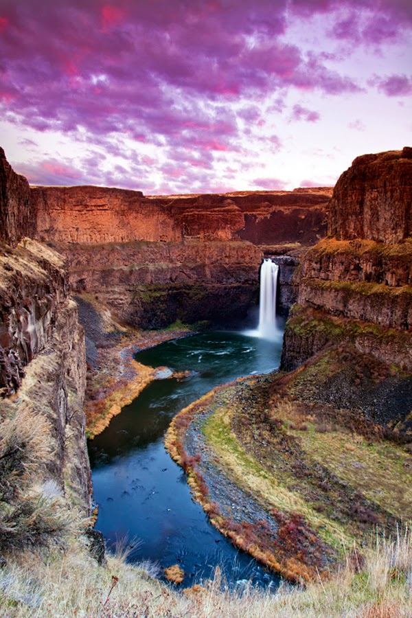
The Palouse Falls lies on the Palouse River, about 4 mi upstream of the confluence with the Snake River in southeast Washington, United States. The falls are 198 ft in height. The falls consists of an upper falls with a drop of ~20 feet which lies 1,000 feet north northwest of the main drop, and a lower falls, with a drop of ~180 feet. The falls are included in Washington State's Palouse Falls State Park, which provides access to the falls and has displays explaining the region's unique geology, as well as its historical ties (the Palouse Indians and the Mullan Road both took advantage of the easy access to the plateau in the vicinity of the falls).
Source: 500px.com/photo/9990571/palouse-falls-by-paul-james
Source: 500px.com/photo/39342650/palouse-falls-portrait-by-michael-brandt
Source: flickr.com/photos/craiggoodwin2/8542133679/in/photostream
Source: 500px.com/photo/11387003/palouse-by-s-amer