The Pont Alexandre III is an arch bridge that spans the Seine, connecting the Champs-Élysées quarter and the Invalides and Eiffel Tower quarter, widely regarded as the most ornate, extravagant bridge in Paris. It is classified as a historical monument. The bridge, with its exuberant Art Nouveau lamps, cherubs, nymphs and winged horses at either end, was built between 1896 and 1900. It is named after Tsar Alexander III, who had concluded the Franco-Russian Alliance in 1892. His son Nicholas II laid the foundation stone in October 1896. The style of the bridge reflects that of the Grand Palais, to which it leads on the right bank.
The construction of the bridge is a marvel of 19th century engineering, consisting of a six-metre high single span steel arch. The design, by the architects Joseph Cassien-Bernard and Gaston Cousin, was subject to strict controls that prevented the bridge from obscuring the view of the Champs-Élysées or the Invalides.
Source: flickr.com/photos/anto13/10378318143/in/faves-41719705@N07/
Bokod is the lake in Hungary, some 80 kilometers west of Budapest. It’s an interesting and beautiful place. Plenty of old fishing houses on the water which look rather romantic with the various wooden bridges. Bokod Hungary is not a tourist destination. It is barely visited – it’s just an old village on a lake. Along the lake shore, rickety boardwalks lead out over the lake to old fishing cottages that stand on stilts. It’s not the nicest location, but I think there’s something enchanting about the photographs, and there is certainly something artsy about the boardwalks and cottages on the misty water.
The Statue of Dacian king Decebalus is a 40-m high statue that is the tallest rock sculpture in Europe. It is located on the Danube's rocky bank, near the city of Orşova, Romania. It was commissioned by Romanian businessman and historian Iosif Constantin Drăgan and it took 10 years, from 1994 to 2004, for twelve sculptors to finish it. The final cost was over one million dollars. Under the face of Decebalus there is a Latin inscription which reads "DECEBALUS REX - DRAGAN FECIT" ("King Decebal - Made by Drăgan"). On the Serbian side facing Romania, there is an ancient memorial plaque (Tabula Traiana) commemorating the victories of the Roman Empire over the Dacian kingdom in 105.
The Oneonta Gorge is in the Columbia River Gorge in the American state of Oregon. The U.S. Forest Service has designated it as a botanical area because of the unique aquatic and woodland plants that grow there. The basalt walls are home to a wide variety of ferns, mosses, hepatics and lichens, many of which grow only in the Columbia River Gorge. Oneonta Creek runs through the gorge. There are four major waterfalls on the creek. Middle Oneonta Falls can be seen clearly from a footpath and is very often mistaken for the upper or lower falls. The lower gorge has been preserved as a natural habitat, so there is no boardwalk or footpath through it as such.
Thus, Lower Oneonta Falls can only be seen by walking upstream from the creek's outlet at the Historic Columbia River Highway. To get to a vantage point where the entire lower falls is visible can require wading through water that in some places can be chest-deep, depending on the season and the relative amount of snow-melt. The upper falls are about 1 mile upstream from the middle falls and require scrambling up the creek or climbing down a canyon wall to view. The fourth falls which is "Triple falls" can be seen from a vantage point on the upper trails in the canyon.
In place names the town bank term is reserved for deeply lining the Grand Canal and the Bacino di San Marco . At the time of the Venetian Republic in fact the existing banks were the quays for berthing of vessels that operated the mercantile trade in the Mediterranean basin . For this reason, the banks are characterized by a width much greater than that of fondamente ordinary and are totally devoid of parapets. The banks are the most famous Riva di Biasio or Biagio, the Riva del Vin and Riva del Carbón along the Grand Canal ; the Riva degli Schiavoni and the Riva dei Sette Martyrs along the Bacino di San Marco .
Source: flickr.com/photos/37759772@N07/10852348584
Angel Falls is a waterfall in Venezuela. It is the world's highest uninterrupted waterfall, with a height of 979 m and a plunge of 807 m. The waterfall drops over the edge of the Auyantepui mountain in the Canaima National Park, a UNESCO World Heritage site in the Gran Sabana region of Bolívar State. The height figure 979 m mostly consists of the main plunge but also includes about 400 m of sloped cascades and rapids below the drop and a 30-metre high plunge downstream of the talus rapids. The falls are on the Gauja River (alternatively known as the Kerep River or Kerepacupai), which flows into the Churun River, a tributary of the Carrao River.
Angel Falls is one of Venezuela's top tourist attractions, though a trip to the falls is a complicated affair. The falls are located in an isolated jungle. A flight from Puerto Ordaz or Ciudad Bolívar is required to reach Canaima camp, the starting point for river trips to the base of the falls. River trips generally take place from June to December, when the rivers are deep enough for the wooden curiaras used by the Pemon guides. During the dry season (December to March) there is less water seen than in the other months (This can be clearly seen in the photos of the falls above)
The Obersee ("Upper Lake") is the larger of the two parts of Lake Constance. It has an area of 473 km² in size and extends over 63 km between Bregenz and Bodman-Ludwigshafen. Its maximum width is 14 km. The Romans called it Lacus Venetus, Lacus Brigantinus and Lacus Constantinus. In the Middle Ages the dominant term was Lacus Bodamicus, or in German Bodensee. Gradually, this name began to include the Untersee (Lacus Acronius), so the term "Upper Lake" was introduced for the larger lake. The Upper Lake is drained by the Seerhein in Constance, which flows into the Lower Lake. Its main tributary is the Alpine Rhine. Parts of the Upper Lake are the Lake Überlingen, the Bregenz Bay and the Constance Hopper. Lake Überlingen is sometimes considered to be a separate lake, in which case the name "Obersee" only refers to the section between Bregenz and Constance.
Source: 500px.com/photo/7240545/boathouse-obersee-by-mark-whale
Source: trending.nl
The Kintai Bridge is a historical wooden arch bridge, in the city of Iwakuni, in Yamaguchi Prefecture, Japan. The bridge was built in 1673, spanning the Nishiki River in a series of five wooden arches. The bridge is located on the foot of Mt.Yokoyama, at the top of which lies Iwakuni Castle.
Kikkou Park, which includes the bridge and castle, is a popular tourist destination in Japan, particularly during the Cherry Blossom festival in the spring and the autumn color change of the Japanese Maples. It was declared a National Treasure in 1922. The bridge is composed of five sequential wooden arch bridges on four stone piers as well as two of wooden piers on the dry riverbed where the bridge begins and ends. Each of the three middle spans is 35.1 meters long, while the two end spans are 34.8 meters for a total length of about 175 meters with a width of 5 meters.
Skradinski buk is one of the most attractive parts of the park. It is a massive, clear, natural pool with high waterfalls at one end and cascades at the other, located in the Krka National Park in Croatia. It is the lowest of the three sets of waterfalls formed along the Krka river. In an area 400 m in length and 100 m in width there are 17 waterfalls and the total difference in height between the first and the last falls is 47.7 m. Due to the wealth and variety of geomorphological forms, vegetation, and the various effects caused by the play of light on the whirlpools, Skradinski buk is considered to be one of the most beautiful calcium carbonate waterfalls in Europe. The rate of flow is 43 m3 a second in winter, 18 m3 in summer, with an average of 55 cubic metres a second flowing down Skradinski buk annually. It is the largest travertine cascade system in Europe.
When you are at the Krka National Park there are several places of interest. The attractions and facilities available are various footpaths, sightseeing tours and presentations, boat trips, souvenir shops, a museum, and restaurants. There are also several archeological remains of unpreserved fortresses in the park's vicinity dating back to as far as the Roman times. They are Čučevo, Nečven, Bogočin, Ključica and Burnum.
Source: flickr.com/photos/rkroenert/10156092003/
Source: 500px.com/photo/4880600/krka-waterfall-by-dusan-milak
Source: flickr.com/photos/sergiu_bacioiu/4404273656/
The Infinity Bridge is a public pedestrian and cycle footbridge across the River Tees in the borough of Stockton-on-Tees in the north-east of England. The bridge is situated one kilometre downriver of Stockton town centre, between the Princess of Wales Bridge and the Tees Barrage and it links the Teesdale Business Park and the University of Durham's Queen's Campus in Thornaby-on-Tees on the south bank of the Tees with the Tees Valley Regeneration's £320 million North Shore development on the north bank. Built at a cost of £15 million with funding from Stockton Borough Council, English Partnerships and its successor body the Homes and Communities Agency, One NorthEast, and the European Regional Development Fund the bridge is a major part of the North Shore Redevelopment Project undertaken by Tees Valley Regeneration.
The bridge had the project title North Shore Footbridge before being given its official name Infinity Bridge, chosen by a panel made from the funding bodies, using names suggested by the public. The name derives from the infinity symbol formed by the bridge and its reflection.
Source: 500px.com/photo/27351257/infinity-bridge-by-anthony-melendrez
Capitol Reef National Park is a United States National Park, in south-central Utah. It is 100 miles long but fairly narrow. The park, established in 1971, preserves 241,904 acres and is open all year, although May through September are the most popular months. Called "Wayne Wonderland" in the 1920s by local boosters Ephraim P. Pectol and Joseph S. Hickman, Capitol Reef National Park protects colorful canyons, ridges, buttes, and monoliths. About 75 mi of the long up-thrust called the Waterpocket Fold, a rugged spine extending from Thousand Lake Mountain to Lake Powell, is preserved within the park. "Capitol Reef" is the name of an especially rugged and spectacular segment of the Waterpocket Fold near the Fremont River. The area was named for a line of white domes and cliffs of Navajo Sandstone, each of which looks somewhat like the United States Capitol building, that run from the Fremont River to Pleasant Creek on the Waterpocket Fold. The local word reef referred to any rocky barrier to travel. Easy road access came with the construction in 1962 of State Route 24 through the Fremont River Canyon.


Source: flickr.com/photos/nwade615/3604733291/in/set-72157619404572016/
Hamilton Pool Preserve is a natural pool that was created when the dome of an underground river collapsed due to massive erosion thousands of years ago. The pool is located about 23 miles west of Austin, Texas off Highway 71. Since the 1960s, Hamilton Pool has been a popular summer swimming spot for Austin visitors and residents. Hamilton Pool Preserve consists of 232 acres of protected natural habitat featuring a jade green pool into which a 50-foot waterfall flows. The pool is surrounded by large slabs of limestone that rest by the water's edge; large stalactites grow from the ceiling high above. The ceiling and surrounding cliffs of the grotto are home to moss, maidenhair fern and cliff swallows. The Ashe juniper (cedar) uplands of the preserve are home to the endangered golden-cheeked warbler. The natural pool and creek are not chemically treated, so water quality is monitored regularly and swimming is occasionally restricted. Hamilton Pool is part of the Balcones Cayonlands Preserve and is a protected environment.


The Waitomo Glowworm Caves attraction is a cave at Waitomo on the North Island of New Zealand, known for its population of glowworms, Arachnocampa luminosa. This species is found exclusively in New Zealand. They are around the size of an average mosquito. This cave is part of the Waitomo Caves system that includes the Ruakuri Cave and the Aranui Cave. The attraction has a modern visitor centre at the entrance, largely designed in wood. There are organized tours that include a boat ride under the glowworms. The most renowned animal in the cave is the glowworm Arachnocampa luminosa. There are several small underwater lakes that were created by freshwater creeks or brooks.
The walls of the caves are covered with a variety of fungi including the cave flower (a distant relation to the genus Pleurotus) that is actually a mushroom-like fungus. The most common animals in the caves are insects. This includes albino cave ants, giant crickets, and of course the glowworms.
Source: 500px.com/photo/56841620/glowing-in-the-dark-by-fabian-ebi
The Liffey is a river in Ireland, which flows through the centre of Dublin. Its major tributaries include the River Dodder, the River Poddle and the River Camac. The river supplies much of Dublin's water, and a range of recreational opportunities. The river was previously named An Ruirthech, meaning "fast (or strong) runner". The word Liphe (or Life) referred originally to the name of the plain through which the river ran, but eventually came to refer to the river itself. It was also known as the Anna Liffey, possibly from an anglicisation of Abhainn na Life, the Irish phrase that translates into English as River Liffey.
Dividing the Northside of Dublin from the Southside, the Liffey is today spanned by numerous bridges, mostly open to vehicular traffic. Notable are the West-Link Bridge on the M50 motorway, the Seán Heuston Bridge and O'Connell Bridge. There are 3-foot-bridges in the city: the Millennium Bridge, the Seán O'Casey Bridge and the Ha'penny Bridge. In December 2009, the new Samuel Beckett Bridge opened. between the Seán O'Casey Bridge and the East Link Bridge, It was designed by Santiago Calatrava Valls, who also designed the James Joyce Bridge that spans the Liffey. The Samuel Beckett Bridge takes both road and pedestrian traffic and in the future it may also take rail traffic. Crossings further upriver include the Liffey Bridge at Celbridge, "The Bridge at 16" (a 19th-century pedestrian suspension bridge at what is now the K Club), and the Leinster Aqueduct – which carries the Grand Canal over the Liffey at Caragh.
Source: trekearth.com/gallery/Europe/Ireland/photo1176781.htm
Source: flickr.com/photos/89677847@N06/8155640110/in/photostream/#
Source: fineartamerica.com/featured/river-liffey-bridges-dublin-ireland-the-irish-image-collection-.html
Source: 500px.com/photo/7282121/north-wall-quay-2-by-gerry-chaney
Lake Tahoe is a large freshwater lake in the Sierra Nevada of the United States. At a surface elevation of 6,225 ft, it is located along the border between California and Nevada, west of Carson City. Lake Tahoe is the largest alpine lake in North America. Its depth is 1,645 ft, making it the second-deepest in the United States (the deepest is Crater Lake in Oregon at 1,945 ft, 300 ft deeper). Additionally, Lake Tahoe is listed as the 27th largest lake by volume in the world at 122,160,280 acre.ft.
The lake was formed about 2 million years ago and is a part of the Lake Tahoe Basin with the modern lake being shaped during the ice ages. It is known for the clarity of its water and the panorama of surrounding mountains on all sides. The area surrounding the lake is also referred to as Lake Tahoe, or simply Tahoe. More than 75% of the lake's watershed is national forest land, comprising the Lake Tahoe Basin Management Unit of the United States Forest Service. Lake Tahoe is a major tourist attraction in both Nevada and California. It is home to a number of ski resorts, summer outdoor recreation, and tourist attractions. Snow and skiing are a significant part of the area's economy and reputation. Mountain and lake scenery are attractions throughout the year. The Nevada side also includes large casinos. Highways provide year-round access from Reno, Carson City, and Sacramento.
Source: spiritpartage.forumactif.com
Source: 500px.com/photo/28072741
Source: flickr.com/photos/gotahoenorth/1031178489/in/pool-northlaketahoe
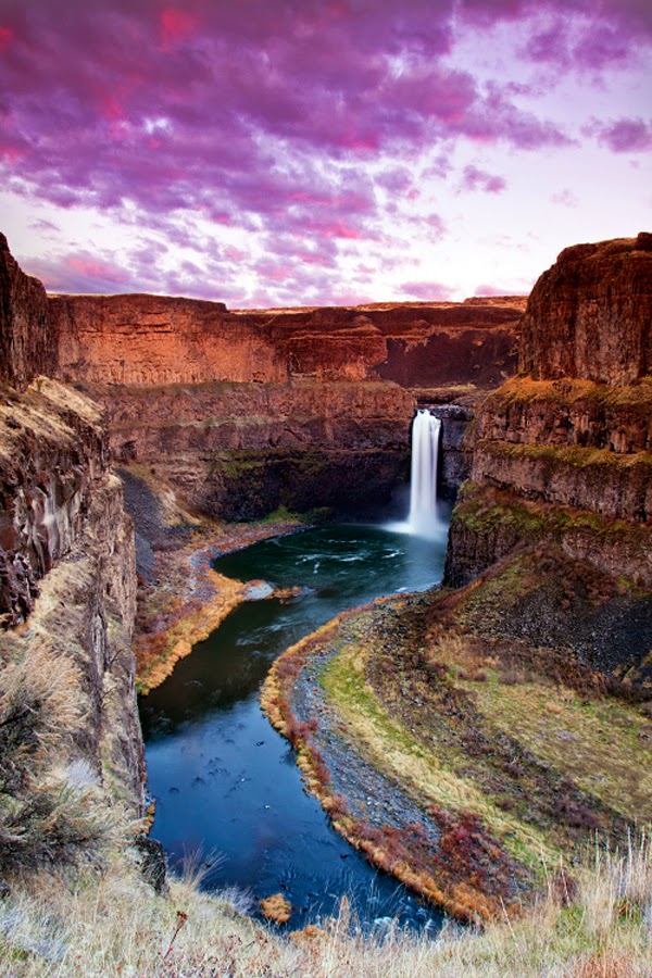
The Palouse Falls lies on the Palouse River, about 4 mi upstream of the confluence with the Snake River in southeast Washington, United States. The falls are 198 ft in height. The falls consists of an upper falls with a drop of ~20 feet which lies 1,000 feet north northwest of the main drop, and a lower falls, with a drop of ~180 feet. The falls are included in Washington State's Palouse Falls State Park, which provides access to the falls and has displays explaining the region's unique geology, as well as its historical ties (the Palouse Indians and the Mullan Road both took advantage of the easy access to the plateau in the vicinity of the falls).
Source: 500px.com/photo/9990571/palouse-falls-by-paul-james
Source: 500px.com/photo/39342650/palouse-falls-portrait-by-michael-brandt
Source: flickr.com/photos/craiggoodwin2/8542133679/in/photostream
Source: 500px.com/photo/11387003/palouse-by-s-amer
The San Antonio River Walk (also known as Paseo del Río) is a network of walkways along the banks of the San Antonio River, one story beneath the streets of Downtown San Antonio, Texas, USA. Lined by bars, shops and restaurants, the River Walk is an important part of the city's urban fabric and a tourist attraction in its own right. Today, the River Walk is an enormously successful special-case pedestrian street, one level down from the automobile street. The River Walk winds and loops under bridges as two parallel sidewalks lined with restaurants and shops, connecting the major tourist draws from the Alamo to Rivercenter Mall, to the Arneson River Theatre, to Marriage Island, to La Villita, to HemisFair Park, to the Tower Life Building, to the San Antonio Museum of Art, and the Pearl Brewery. During the annual springtime Fiesta San Antonio, the River Parade features flowery floats that float down the river.
The River Walk has inspired similar projects in other cities, such as the Little Sugar Creek Greenway in Charlotte, North Carolina, the Cherry Creek Greenway in Denver, Colorado, and the Santa Lucía Riverwalk in Monterrey, Mexico. After years of murmuring from locals and tourists about the water's quality, talk has also begun about cleaning up the water, although the muddy bottom and silt deposits make this difficult. The muddy bottom does receive an annual cleaning during the Mud Festival.
Source: flickr.com/photos/visitsanantonio
Source: flickr.com/photos/dfikar1/8755726758/
Source: 500px.com/photo/16143515
Source: flickr.com/photos/visitsanantonio
Source: flickr.com/photos/brianmoranhdr/5599476230/in/pool-669451@N20%7Cbrianmoranhdr
Source: flickr.com/photos/visitsanantonio
Fly Geyser, also known as Fly Ranch Geyser is a man-made small geothermal geyser located in Washoe County, Nevada approximately 20 miles north of Gerlach. Fly Geyser is located near the edge of Fly Reservoir and is only about 5 feet high, but 12 feet counting the mound on which it sits in 2013. Fly Geyser is located on the private Fly Ranch in Hualapai Flat, about 0.3 miles from State Route 34. The ranch is currently owned by Todd Jaksick. There is a high fence and a locked gate topped with spikes to exclude trespassers. The only access is a dirt road, but it is large enough to be seen from the road.
Fly Geyser is not an entirely natural phenomenon; it was accidentally created by well drilling in 1964 exploring for sources of geothermal energy. The well may not have been capped correctly, or left unplugged, but either way dissolved minerals started rising and accumulating, creating the travertine mound on which the geyser sits and continues growing. Water is constantly released, reaching 5 feet in the air. The geyser contains several terraces discharging water into 30 to 40 pools over an area of 30 hectares. The geyser is made up of a series of different minerals, but its brilliant colors are due to thermophilic algae.
Source: 500px.com/photo/9017548/anywhere-out-of-this-world-by-christian-klepp
Source: 500px.com/photo/8623727
Source: fineartamerica.com/featured/fly-by-night-don-hall.html
Source: fineartamerica.com/featured/fly-geyser--night-deryk-baumgaertner.html
A cable-stayed bridge has one or more towers (or pylons), from which cables support the bridge deck. There are two major classes of cable-stayed bridges: harp and fan. In the harp or parallel design, the cables are nearly parallel so that the height of their attachment to the tower is proportional to the distance from the tower to their mounting on the deck. In the fan design, the cables all connect to or pass over the top of the towers. The fan design is structurally superior with minimum moment applied to the towers but for practical reasons the modified fan is preferred especially where many cables are necessary. In the modified fan arrangement the cables terminate near to the top of the tower but are spaced from each other sufficiently to allow better termination, improved environmental protection, and good access to individual cables for maintenance.
The cable-stayed bridge is optimal for spans longer than cantilever bridges, and shorter than suspension bridges. This is the range where cantilever bridges would rapidly grow heavier if the span were lengthened, and suspension bridge cabling would not be more economical if the span were shortened.
Source: 500px.com/photo/60834662/suspension-bridge-portimao-algarve-portugal-by-joe-daniel-price
Source: flickr.com/photos/suzyesue/4103186727/