Shiprock is a census-designated place (CDP) in San Juan County, New Mexico, United States, on the Navajo reservation. The population was 8,156 at the 2000 census. It is part of the Farmington Metropolitan Statistical Area. Shiprock is named after the nearby Shiprock rock formation. It is home to the annual Northern Navajo Fair, held every October. Since 1984, the community has been the host of the Shiprock Marathon and Relay. It is also home to a campus of Diné College (formerly Navajo Community College), a tribally controlled community college with seven other campuses across the Navajo Nation. It is the site of a Chapter House for the Navajo, a Bureau of Indian Affairs agency, the Northern Navajo Medical Center (an Indian Health Service hospital), and a branch of Farmington Public Library. Shiprock is a key road junction for truck traffic and tourists visiting the Four Corners, Mesa Verde, Shiprock and the Grand Canyon. The town lies at the intersection of U.S. Highway 64 and U.S. Highway 491 (formerly U.S. Highway 924).

Source: fineartamerica.com/products/shiprock-inge-johnsson-poster.html
The Oneonta Gorge is in the Columbia River Gorge in the American state of Oregon. The U.S. Forest Service has designated it as a botanical area because of the unique aquatic and woodland plants that grow there. The basalt walls are home to a wide variety of ferns, mosses, hepatics and lichens, many of which grow only in the Columbia River Gorge. Oneonta Creek runs through the gorge. There are four major waterfalls on the creek. Middle Oneonta Falls can be seen clearly from a footpath and is very often mistaken for the upper or lower falls. The lower gorge has been preserved as a natural habitat, so there is no boardwalk or footpath through it as such.
Thus, Lower Oneonta Falls can only be seen by walking upstream from the creek's outlet at the Historic Columbia River Highway. To get to a vantage point where the entire lower falls is visible can require wading through water that in some places can be chest-deep, depending on the season and the relative amount of snow-melt. The upper falls are about 1 mile upstream from the middle falls and require scrambling up the creek or climbing down a canyon wall to view. The fourth falls which is "Triple falls" can be seen from a vantage point on the upper trails in the canyon.
Biscayne National Park is a U.S. National Park located in southern Florida, south of Miami. The park preserves Biscayne Bay and its offshore barrier reefs, some of the best scuba diving and snorkeling areas in the United States. Ninety-five percent of the park is water, and the shore of the bay is the location of an extensive mangrove forest. The park covers 172,971 acres and includes Elliott Key, the park's largest island and first of the true Florida Keys, formed from fossilized coral reef. The islands farther north in the park are transitional islands of coral and sand. The offshore portion of the park includes the northernmost region of the Florida Reef, one of the largest coral reefs in the world.
Source: flickr.com/photos/radiology/4532403238/in/photostream/
Daily living becomes streamlined through unique design solutions. Whether it is a hidden doorway through a bookcase or a concealed vanity niche, the complexities of our lives can be resolved through elegant organization. When you enter a Deep River home, you notice the spaces, the atmosphere and the quality of design at every turn. What you do not see are the technical components that assist to enhance that atmosphere. The result is a home that reflects the personality of the owner, not the mechanisms that operate it. Through design innovation they create practical solutions that, when combined together; create a home that is truly yours.
Source: deep-river.com/design-philosophy/recreate/
Discover Marriott's Maui Ocean Club - Molokai, Maui & Lanai Towers in beautiful Ka'anapali Beach. A jewel amongst Ka'anapali beach resorts, It's located in one of the most desirable destinations in Maui. Their guestrooms, one- and two-bedroom suites at this stunning beach resort in Maui offer elegance and comfort in an ideal location. Featuring an array of fabulous amenities unrivaled by other Ka'anapali beach resorts, their spacious suites include separate living and dining areas, a wet bar with bar-sized refrigerator, sink and dishwasher, and private balconies with scenic views. Enjoy the fantastic 3.5-acre superpool, rejuvenating on-site spa and wellness center, several nearby golf courses, a premium fitness center and many great dining options. Ideally located in Lahaina, Maui beach resort is just moments away from premier attractions like Whalers Village, Front Street and Lahaina Cannery Mall. Discover luxurious suite accommodations at Hawaiian beach resort at Marriott's Maui Ocean Club.
Spacious Lahaina beach resort accommodations and appealing amenities include eclectic dining, golf, tennis and watersports. Families will love the 3.5-acre super pool with slides, waterfalls, grottos, spas and a shipwreck play area for children. Beautiful Lahaina, Maui beach resort overlooks Ka'anapali Beach and is located within proximity of top attractions. Source: www.marriott.com
Source: flickr.com/photos/67281146@N08/6577522493
The cathedrals of the Middle Ages were massive structures which architecturally expressed a great age of faith. Based on the pointed Gothic arch, these magnificent cathedrals were constructed in a symmetrical style with repetitive elements. The same influence is visible in the Mildred B. Cooper Memorial Chapel. Designed by architect, E. Fay Jones and Maurice Jennings of Fayetteville, AR, the chapel is constructed around 15 main arches towering 50 feet high. Within each of the 15 arches are three or four Gothic arches. The Gothic style was chosen for its enduring quality, a quality which is as awe inspiring today as it was in Fourteenth Century Europe. The individuality of the chapel lies not in its links with the past but in its departure from the materials used in those ancient structures.
Glass and steel are the building blocks which exemplify modern man. Thirty-one tons of steel join 4,460 square feet of glass to create its aura of strength, yet weightlessness. Positioned on a wooded hilltop overlooking Lake Norwood, the Chapel is encompassed by towering pines and stately oaks. Because the Chapel's structure is transparent, patterns of light and shadow create an ever changing interior influenced by nature's season at hand. Visitors are invited to experience the peace and serenity of the Chapel, which offers an extraordinary setting for meditation, personal reflection or a place to just relax and enjoy. Special ceremonies such as marriages, renewal of vows, concerts, cultural events, baptisms and memorial services are welcomed. But whether you are touring the Chapel or attending a special service, you will leave the Mildred B. Cooper Memorial Chapel with a unique sense of renewed spirit.
Source: batteredluggage.com
Source: flickr.com/photos/justice42/2612994259/in/photostream/
Source: flickr.com/photos/bharding56/4767171675/in/photostream/
Source: flickr.com/photos/bharding56/4767171675/in/photostream/
Capitol Reef National Park is a United States National Park, in south-central Utah. It is 100 miles long but fairly narrow. The park, established in 1971, preserves 241,904 acres and is open all year, although May through September are the most popular months. Called "Wayne Wonderland" in the 1920s by local boosters Ephraim P. Pectol and Joseph S. Hickman, Capitol Reef National Park protects colorful canyons, ridges, buttes, and monoliths. About 75 mi of the long up-thrust called the Waterpocket Fold, a rugged spine extending from Thousand Lake Mountain to Lake Powell, is preserved within the park. "Capitol Reef" is the name of an especially rugged and spectacular segment of the Waterpocket Fold near the Fremont River. The area was named for a line of white domes and cliffs of Navajo Sandstone, each of which looks somewhat like the United States Capitol building, that run from the Fremont River to Pleasant Creek on the Waterpocket Fold. The local word reef referred to any rocky barrier to travel. Easy road access came with the construction in 1962 of State Route 24 through the Fremont River Canyon.


Source: flickr.com/photos/nwade615/3604733291/in/set-72157619404572016/
Hamilton Pool Preserve is a natural pool that was created when the dome of an underground river collapsed due to massive erosion thousands of years ago. The pool is located about 23 miles west of Austin, Texas off Highway 71. Since the 1960s, Hamilton Pool has been a popular summer swimming spot for Austin visitors and residents. Hamilton Pool Preserve consists of 232 acres of protected natural habitat featuring a jade green pool into which a 50-foot waterfall flows. The pool is surrounded by large slabs of limestone that rest by the water's edge; large stalactites grow from the ceiling high above. The ceiling and surrounding cliffs of the grotto are home to moss, maidenhair fern and cliff swallows. The Ashe juniper (cedar) uplands of the preserve are home to the endangered golden-cheeked warbler. The natural pool and creek are not chemically treated, so water quality is monitored regularly and swimming is occasionally restricted. Hamilton Pool is part of the Balcones Cayonlands Preserve and is a protected environment.


If you’ve had the opportunity to visit one of Ra Paulette’s art caves in the Embudo area, the word “transcendent” might occur to you when describing the experience. “I call it the cave effect,” Paulette said. “There are some perceptual and psychological things that are in play, as far as a medium goes, that are advantages in this work.” And work it is. The process of creating his underground cathedrals is intensely physical, as viewers of CaveDigger will see. The new documentary film screens at the Center for Contemporary Art on Tuesday and Sunday, July 9 and 14. Even though his medium is relatively soft sandstone, it is rock, and the cave sites are remote. You get an inkling of the effort involved when you observe Paulette trudging, climbing over the landscape on his way to his current cave project, a wheelbarrow and tools strapped to his back. Then there’s all the digging and carving, creating arches and walls, shoveling all the loose stuff into the barrow, and hauling it outside the cave entrance.
Source: www.santafenewmexican.com
Source: buro247.com/images
Other Images from : flickr.com/photos/hnicpena/12077519305/in/photostream & santafesir.com
Dry lightning is a term which is used to refer to lightning strikes occurring without significant precipitation. The term is a technical misnomer since lightning itself is neither wet nor dry, and also because the thunderstorms which sometimes cause it actually do produce precipitation, although the precipitation does not reach the ground in significant amounts.
Source: www.abqphotographersgallery.com/knate-myers.html
Lake Tahoe is a large freshwater lake in the Sierra Nevada of the United States. At a surface elevation of 6,225 ft, it is located along the border between California and Nevada, west of Carson City. Lake Tahoe is the largest alpine lake in North America. Its depth is 1,645 ft, making it the second-deepest in the United States (the deepest is Crater Lake in Oregon at 1,945 ft, 300 ft deeper). Additionally, Lake Tahoe is listed as the 27th largest lake by volume in the world at 122,160,280 acre.ft.
The lake was formed about 2 million years ago and is a part of the Lake Tahoe Basin with the modern lake being shaped during the ice ages. It is known for the clarity of its water and the panorama of surrounding mountains on all sides. The area surrounding the lake is also referred to as Lake Tahoe, or simply Tahoe. More than 75% of the lake's watershed is national forest land, comprising the Lake Tahoe Basin Management Unit of the United States Forest Service. Lake Tahoe is a major tourist attraction in both Nevada and California. It is home to a number of ski resorts, summer outdoor recreation, and tourist attractions. Snow and skiing are a significant part of the area's economy and reputation. Mountain and lake scenery are attractions throughout the year. The Nevada side also includes large casinos. Highways provide year-round access from Reno, Carson City, and Sacramento.
Source: spiritpartage.forumactif.com
Source: 500px.com/photo/28072741
Source: flickr.com/photos/gotahoenorth/1031178489/in/pool-northlaketahoe
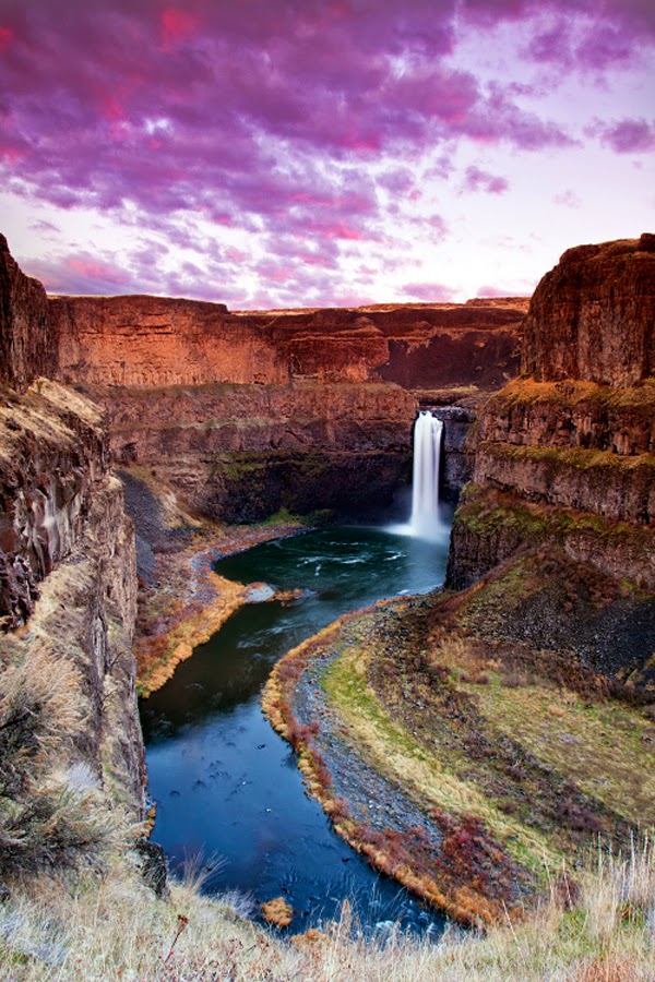
The Palouse Falls lies on the Palouse River, about 4 mi upstream of the confluence with the Snake River in southeast Washington, United States. The falls are 198 ft in height. The falls consists of an upper falls with a drop of ~20 feet which lies 1,000 feet north northwest of the main drop, and a lower falls, with a drop of ~180 feet. The falls are included in Washington State's Palouse Falls State Park, which provides access to the falls and has displays explaining the region's unique geology, as well as its historical ties (the Palouse Indians and the Mullan Road both took advantage of the easy access to the plateau in the vicinity of the falls).
Source: 500px.com/photo/9990571/palouse-falls-by-paul-james
Source: 500px.com/photo/39342650/palouse-falls-portrait-by-michael-brandt
Source: flickr.com/photos/craiggoodwin2/8542133679/in/photostream
Source: 500px.com/photo/11387003/palouse-by-s-amer
The White Sands National Monument is a U.S. National Monument located about 25 km southwest of Alamogordo in western Otero County and northeastern Doña Ana County in the state of New Mexico, at an elevation of 4235 feet. The area is in the mountain-ringed Tularosa Basin and comprises the southern part of a 710-km² field of white sand dunes composed of gypsum crystals. It is the largest gypsum dune field in the world.
Gypsum is rarely found in the form of sand because it is water-soluble. Normally, rain would dissolve the gypsum and carry it to the sea. The Tularosa Basin is enclosed, meaning that it has no outlet to the sea and that rain that dissolves gypsum from the surrounding San Andres and Sacramento Mountains is trapped within the basin. Thus water either sinks into the ground or forms shallow pools which subsequently dry out and leave gypsum in a crystalline form, called selenite, on the surface. Groundwater that does flow out of the Tularosa Basin flows south into the Hueco Basin. During the last ice age, a lake known as Lake Otero covered much of the basin. When it dried out, it left a large flat area of selenite crystals which is now the Alkali Flat. Another lake, Lake Lucero, at the southwest corner of the park, is a dry lake bed, at one of the lowest points of the basin, which occasionally fills with water.
Source: menaker.com/photo/1119
Source: russbishop.photoshelter.com/gallery-image/Signature-Series-Fine-Art-Prints/G0000VcaKKF6NLWU/I000040eQbPlYbKo
Source: flickr.com/photos/gakout/6143653393/sizes/l/in/photostream/
The San Antonio River Walk (also known as Paseo del Río) is a network of walkways along the banks of the San Antonio River, one story beneath the streets of Downtown San Antonio, Texas, USA. Lined by bars, shops and restaurants, the River Walk is an important part of the city's urban fabric and a tourist attraction in its own right. Today, the River Walk is an enormously successful special-case pedestrian street, one level down from the automobile street. The River Walk winds and loops under bridges as two parallel sidewalks lined with restaurants and shops, connecting the major tourist draws from the Alamo to Rivercenter Mall, to the Arneson River Theatre, to Marriage Island, to La Villita, to HemisFair Park, to the Tower Life Building, to the San Antonio Museum of Art, and the Pearl Brewery. During the annual springtime Fiesta San Antonio, the River Parade features flowery floats that float down the river.
The River Walk has inspired similar projects in other cities, such as the Little Sugar Creek Greenway in Charlotte, North Carolina, the Cherry Creek Greenway in Denver, Colorado, and the Santa Lucía Riverwalk in Monterrey, Mexico. After years of murmuring from locals and tourists about the water's quality, talk has also begun about cleaning up the water, although the muddy bottom and silt deposits make this difficult. The muddy bottom does receive an annual cleaning during the Mud Festival.
Source: flickr.com/photos/visitsanantonio
Source: flickr.com/photos/dfikar1/8755726758/
Source: 500px.com/photo/16143515
Source: flickr.com/photos/visitsanantonio
Source: flickr.com/photos/brianmoranhdr/5599476230/in/pool-669451@N20%7Cbrianmoranhdr
Source: flickr.com/photos/visitsanantonio
Fly Geyser, also known as Fly Ranch Geyser is a man-made small geothermal geyser located in Washoe County, Nevada approximately 20 miles north of Gerlach. Fly Geyser is located near the edge of Fly Reservoir and is only about 5 feet high, but 12 feet counting the mound on which it sits in 2013. Fly Geyser is located on the private Fly Ranch in Hualapai Flat, about 0.3 miles from State Route 34. The ranch is currently owned by Todd Jaksick. There is a high fence and a locked gate topped with spikes to exclude trespassers. The only access is a dirt road, but it is large enough to be seen from the road.
Fly Geyser is not an entirely natural phenomenon; it was accidentally created by well drilling in 1964 exploring for sources of geothermal energy. The well may not have been capped correctly, or left unplugged, but either way dissolved minerals started rising and accumulating, creating the travertine mound on which the geyser sits and continues growing. Water is constantly released, reaching 5 feet in the air. The geyser contains several terraces discharging water into 30 to 40 pools over an area of 30 hectares. The geyser is made up of a series of different minerals, but its brilliant colors are due to thermophilic algae.
Source: 500px.com/photo/9017548/anywhere-out-of-this-world-by-christian-klepp
Source: 500px.com/photo/8623727
Source: fineartamerica.com/featured/fly-by-night-don-hall.html
Source: fineartamerica.com/featured/fly-geyser--night-deryk-baumgaertner.html