Bokod is the lake in Hungary, some 80 kilometers west of Budapest. It’s an interesting and beautiful place. Plenty of old fishing houses on the water which look rather romantic with the various wooden bridges. Bokod Hungary is not a tourist destination. It is barely visited – it’s just an old village on a lake. Along the lake shore, rickety boardwalks lead out over the lake to old fishing cottages that stand on stilts. It’s not the nicest location, but I think there’s something enchanting about the photographs, and there is certainly something artsy about the boardwalks and cottages on the misty water.
Melissani Cave or Melissani Lake, also Melisani is a cave located on the island of Kefalonia, northwest of Sami, about 5 km SE of Agia Efthymia, NE of Argostoli and NW of Poros. The Ionian Sea lies to the east with the Strait of Ithaca. Forests surrounds the cave and the mountain slope is to the west. Near the cave is the entry to the cave with parking lots and is passed almost in the middle of the main road linking Sami and Agia Efimia especially to the northern part of the island. In Greek mythology, Melissani was the cave of the nymphs. The cave features a lake that are surrounded with trees and forests. The cave is located east of the mountains of Evmorfia and Agia Dynati. Tourism is common in the cave. The cave features a sky-blue lake covered with stones at the bottom. Plants are at the door of the cave. The color of the rocks which are stucco to honey-like brown is at the door of the cave. The lake is also inside the cave. The cave was rediscovered in 1951 by Giannis Petrocheilos.


The Obersee ("Upper Lake") is the larger of the two parts of Lake Constance. It has an area of 473 km² in size and extends over 63 km between Bregenz and Bodman-Ludwigshafen. Its maximum width is 14 km. The Romans called it Lacus Venetus, Lacus Brigantinus and Lacus Constantinus. In the Middle Ages the dominant term was Lacus Bodamicus, or in German Bodensee. Gradually, this name began to include the Untersee (Lacus Acronius), so the term "Upper Lake" was introduced for the larger lake. The Upper Lake is drained by the Seerhein in Constance, which flows into the Lower Lake. Its main tributary is the Alpine Rhine. Parts of the Upper Lake are the Lake Überlingen, the Bregenz Bay and the Constance Hopper. Lake Überlingen is sometimes considered to be a separate lake, in which case the name "Obersee" only refers to the section between Bregenz and Constance.
Source: 500px.com/photo/7240545/boathouse-obersee-by-mark-whale
Source: trending.nl
The Kintai Bridge is a historical wooden arch bridge, in the city of Iwakuni, in Yamaguchi Prefecture, Japan. The bridge was built in 1673, spanning the Nishiki River in a series of five wooden arches. The bridge is located on the foot of Mt.Yokoyama, at the top of which lies Iwakuni Castle.
Kikkou Park, which includes the bridge and castle, is a popular tourist destination in Japan, particularly during the Cherry Blossom festival in the spring and the autumn color change of the Japanese Maples. It was declared a National Treasure in 1922. The bridge is composed of five sequential wooden arch bridges on four stone piers as well as two of wooden piers on the dry riverbed where the bridge begins and ends. Each of the three middle spans is 35.1 meters long, while the two end spans are 34.8 meters for a total length of about 175 meters with a width of 5 meters.
Abraham Lake is an artificial lake on North Saskatchewan River in western Alberta, Canada. Abraham Lake has a surface area of 53.7 km2 and a length of 32 km. It was built on the upper course of the North Saskatchewan River, in the foothills of the Canadian Rockies. It lines David Thompson Highway between Saskatchewan River Crossing and Nordegg. Abraham Lake was created in 1972, with the construction of the Bighorn Dam. The Government of Alberta sponsored a contest to name the lake in February 1972, during the final stages of construction of the Bighorn dam. Students across the province were asked to submit names taking into consideration "historical significance, prominent persons, geography and topography, and the value of the lake." It was named for Silas Abraham, an inhabitant of the Saskatchewan River valley in the nineteenth century. Although man-made, the lake has the blue color of other glacial lakes in the Rocky Mountains, which is caused by rock flour as in other glacial lakes. The Cline River Heliport is located on the western shore of the lake.

Source: naked-science.ru
The ARC River Culture Pavilion, designed by New York-based multi-disciplinary design studio Asymptote Architecture, is located on an artificial river peninsula in South Korea as part of the World Expo 2012. It is a stunning silver-skinned ovaloid that seems to rise out of the semi-rural landscape on the outskirts of Daegu, a city of 2.5 million. The structure features a silver pillow-clad shape which is a powerful formal statement that combines nature, technology and space.
Descriptin from Asymptote Architecture: “The building is a strong focal point set against a stunning panoramic landscape. The architecture is comprised of a vessel shaped form that is clad in silver fritted ETFE pillows that through a play of transparency and geometry creates an ephemeral effect. This atmospheric quality of the building enclosure is heightened by light reflections from shallow pool of water that surrounds the base. While the visible portion of the building sits atop an artificially formed landscape, the exhibition gallery concealed below is the space through which the visitors enter. While the exterior of the ETFE clad structure captures the quality of the changing light with the open sky and river landscape as backdrop, the darkened and hermetic interior of the main structure houses an immersive multimedia environment illuminated only by projections of the abstracted and re-conceptualized qualities of the surrounding site.”
Source: designdiffusion.com/en/architecture-eng/a-silver-skinned-pavilion-by-asymptote-architecture/
The Infinity Bridge is a public pedestrian and cycle footbridge across the River Tees in the borough of Stockton-on-Tees in the north-east of England. The bridge is situated one kilometre downriver of Stockton town centre, between the Princess of Wales Bridge and the Tees Barrage and it links the Teesdale Business Park and the University of Durham's Queen's Campus in Thornaby-on-Tees on the south bank of the Tees with the Tees Valley Regeneration's £320 million North Shore development on the north bank. Built at a cost of £15 million with funding from Stockton Borough Council, English Partnerships and its successor body the Homes and Communities Agency, One NorthEast, and the European Regional Development Fund the bridge is a major part of the North Shore Redevelopment Project undertaken by Tees Valley Regeneration.
The bridge had the project title North Shore Footbridge before being given its official name Infinity Bridge, chosen by a panel made from the funding bodies, using names suggested by the public. The name derives from the infinity symbol formed by the bridge and its reflection.
Source: 500px.com/photo/27351257/infinity-bridge-by-anthony-melendrez
Lake Tahoe is a large freshwater lake in the Sierra Nevada of the United States. At a surface elevation of 6,225 ft, it is located along the border between California and Nevada, west of Carson City. Lake Tahoe is the largest alpine lake in North America. Its depth is 1,645 ft, making it the second-deepest in the United States (the deepest is Crater Lake in Oregon at 1,945 ft, 300 ft deeper). Additionally, Lake Tahoe is listed as the 27th largest lake by volume in the world at 122,160,280 acre.ft.
The lake was formed about 2 million years ago and is a part of the Lake Tahoe Basin with the modern lake being shaped during the ice ages. It is known for the clarity of its water and the panorama of surrounding mountains on all sides. The area surrounding the lake is also referred to as Lake Tahoe, or simply Tahoe. More than 75% of the lake's watershed is national forest land, comprising the Lake Tahoe Basin Management Unit of the United States Forest Service. Lake Tahoe is a major tourist attraction in both Nevada and California. It is home to a number of ski resorts, summer outdoor recreation, and tourist attractions. Snow and skiing are a significant part of the area's economy and reputation. Mountain and lake scenery are attractions throughout the year. The Nevada side also includes large casinos. Highways provide year-round access from Reno, Carson City, and Sacramento.
Source: spiritpartage.forumactif.com
Source: 500px.com/photo/28072741
Source: flickr.com/photos/gotahoenorth/1031178489/in/pool-northlaketahoe
Strome Castle is a ruined castle on the shore of Loch Carron in Stromemore, 3.5 miles south-west of the village of Lochcarron, on the west coast of the Scottish Highlands. Originally built by the Macdonald Earls of Ross. Later in 1472 the castle was owned by the Clan MacDonald of Lochalsh and Alan MacDonald Dubh, 12th Chief of the Clan Cameron was constable on behalf of the MacDonalds of Lochalsh. In 1539 King James V of Scotland granted the castle to the Clan MacDonnell of Glengarry and Hector Munro, chief of the Clan Munro was constable of the castle for the MacDonalds of Glengarry.
Later in 1602 the castle was besieged by Kenneth Mackenzie, 1st Lord Mackenzie of Kintail, chief of the Clan Mackenzie, assisted by their allies the Clan Matheson. After the MacDonalds surrendered it was demolished and blown up. The MacDonnells of Glengarry built a new castle called Invergarry Castle. In 1939 the ruined Strome Castle was presented to the National Trust for Scotland. Today the castle comprises a courtyard and the remains of a square tower.
Source: 500px.com/photo/21934709/strome-castle-ruins-by-gavin-johnson
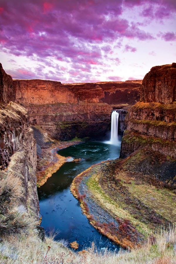
The Palouse Falls lies on the Palouse River, about 4 mi upstream of the confluence with the Snake River in southeast Washington, United States. The falls are 198 ft in height. The falls consists of an upper falls with a drop of ~20 feet which lies 1,000 feet north northwest of the main drop, and a lower falls, with a drop of ~180 feet. The falls are included in Washington State's Palouse Falls State Park, which provides access to the falls and has displays explaining the region's unique geology, as well as its historical ties (the Palouse Indians and the Mullan Road both took advantage of the easy access to the plateau in the vicinity of the falls).
Source: 500px.com/photo/9990571/palouse-falls-by-paul-james
Source: 500px.com/photo/39342650/palouse-falls-portrait-by-michael-brandt
Source: flickr.com/photos/craiggoodwin2/8542133679/in/photostream
Source: 500px.com/photo/11387003/palouse-by-s-amer
Spotted Lake is a saline endorheic alkali lake located northwest of Osoyoos in British Columbia in Canada. It is located near the city of Osoyoos, beside Highway 3. Spotted Lake is very highly concentrated with numerous different minerals. It contains some of the highest quantities (in the world) of magnesium sulfate, calcium and sodium sulphates. It also contains extremely high concentrations of eight other minerals as well as some small doses of four others such as silver and titanium.
Most of the water in the lake evaporates over the summer, leaving behind all the minerals. Large “spots” on the lake appear and depending on the mineral composition at the time, the spots will be different colors. The spots are made mainly of magnesium sulfate, which crystallizes in the summer. In the summer only the minerals in the lake remain, and they harden to form natural “walkways” around and between the spots. Today there is a small sign nearby telling visitors about the lake’s healing powers. However a fence protects the lake-shore from liabilities of public access. Nevertheless the lake can be easily seen from nearby roads, and many do stop to admire.
Source: traveler.es
Source: myrockymountainwindow.files.wordpress.com/
Source: worldfortravel.com
A cable-stayed bridge has one or more towers (or pylons), from which cables support the bridge deck. There are two major classes of cable-stayed bridges: harp and fan. In the harp or parallel design, the cables are nearly parallel so that the height of their attachment to the tower is proportional to the distance from the tower to their mounting on the deck. In the fan design, the cables all connect to or pass over the top of the towers. The fan design is structurally superior with minimum moment applied to the towers but for practical reasons the modified fan is preferred especially where many cables are necessary. In the modified fan arrangement the cables terminate near to the top of the tower but are spaced from each other sufficiently to allow better termination, improved environmental protection, and good access to individual cables for maintenance.
The cable-stayed bridge is optimal for spans longer than cantilever bridges, and shorter than suspension bridges. This is the range where cantilever bridges would rapidly grow heavier if the span were lengthened, and suspension bridge cabling would not be more economical if the span were shortened.
Source: 500px.com/photo/60834662/suspension-bridge-portimao-algarve-portugal-by-joe-daniel-price
Source: flickr.com/photos/suzyesue/4103186727/
Hallstatt, Upper Austria, is a village in the Salzkammergut, a region in Austria. It is located near the Hallstätter lake. At the 2001 census, it had 946 inhabitants. Alexander Scheutz has been mayor of Hallstatt since 2009. Hallstatt is known for its production of salt, dating back to prehistoric times, and gave its name to the Hallstatt culture, a culture often linked to Celtic, Proto-Celtic, and pre-Illyrian peoples in Early Iron Age Europe, c.800–450 BC. Some of the earliest archaeological evidence for the Celts was found in Hallstatt. Salt was a valuable resource, so the region was historically very wealthy. It is possible to tour the world's first known salt mine, located above downtown Hallstatt.
The village also gave its name to the early Iron Age Hallstatt culture and is a World Heritage Site for Cultural Heritage. Hallstatt is a popular tourist attraction owing to its small-town appeal and can be toured on foot in ten minutes.
Source: 500px.com/photo/15097653/rainy-night-in-hallstatt-by-s-srichuwong
Source: 500px.com/photo/37357426/welcome-hallstatt-by-navalarp-teratanatorn
Source: afeeftannous.com/still_life
Source: 500px.com/photo/4272297/living-on-the-hillside
The Sonoran Desert is a North American desert which covers large parts of the Southwestern United States in Arizona and California, and of Northwestern Mexico in Sonora, Baja California and Baja California Sur. It is one of the largest and hottest deserts in North America, with an area of 280,000 square kilometers. The western portion of the United States–Mexico border passes through the Sonoran Desert.
In phytogeography, the Sonoran Desert is within the Sonoran Floristic Province of the Madrean Region in southwestern North America, part of the Holarctic Kingdom of the northern Western Hemisphere. The desert contains a variety of unique and endemic plants and animals, such as the Saguaro (Carnegiea gigantea) and Organ Pipe cactus (Stenocereus thurberi). Many plants not only survive, but thrive in the harsh conditions of the Sonoran Desert. Many have evolved to have specialized adaptations to the desert climate. The Sonoran Desert's bi-seasonal rainfall pattern results in more plant species than in the other North America deserts. The Sonoran Desert includes plant genera and species from the agave family, palm family, cactus family, legume family, and numerous others.
Source: 500px.com/photo/14324657/sunlight-sunshower-by-ben-elliott
Source: 500px.com/photo/35290970/untitled-by-scott-mcguire
Source: 500px.com/photo/29708323/almost-light-by-peter-coskun
Source: fineartamerica.com/featured/sonoran-sunrise-saija-lehtonen.html
Island Park is a city in Fremont County, Idaho, United States. The city's population was 286 at the 2010 census, up from 215 in 2000. The city was incorporated by owners of the many lodges and resorts along U.S. Route 20 in 1947, primarily to circumvent Idaho's liquor laws that prohibited the sale of liquor outside of city limits. It is only 500 feet wide in most locations and, at 33 miles, claims to have the longest "Main Street" in the world. Island Park is part of the Rexburg Micropolitan Statistical Area.
Source: carynesplin.com/wp-content/uploads/2011/08/CarynEsplin_IslandParkHDR.jpg
Lake McDonald is the largest lake in Glacier National Park. It is located at 48°35′N 113°55′W in Flathead County in the U.S. state of Montana. Lake McDonald is approximately 10 miles long, and over a mile wide and 472 feet deep, filling a valley formed by a combination of erosion and glacial activity. Lake McDonald lies at an elevation of 3,153 feet and is on the west side of the Continental Divide. The Going-to-the-Sun Road parallels the lake along its southern shoreline. The surface area of the lake is 6,823 acres.
The lake is home to numerous native species of trout, and other game fish. Catchable species include, but are not limited to - cutthroat trout, rainbow trout, bull trout (char), lake trout (char), Lake Superior whitefish, mountain whitefish, kokanee salmon (landlocked sockeye), and suckers. However, the lake is nutrient-poor and is not considered a prime fishing destination. Grizzly bears, black bear, moose, and mule deer are found in many places near the lake but are most common on the north shore. The lake is surrounded by a dense coniferous forest dominated by various species of spruce, fir, and larch. At the westernmost section of the lake in Apgar there is a National Park Service visitor center, limited lodging and dining facilities as well as outboard powerboats available for rental. Lake McDonald Lodge is the largest lodging facility on the lake and is approximately 5 miles east along the Going-to-the-Sun Road. McDonald Creek flows into and drains from the lake, and empties into the Middle Fork Flathead River shortly after.

Source: 500px.com/photo/44263072/lake-mcdonald-by-jason-savage
Source: flickr.com/photos/ryandyar/13277176145/in/faves-sheldonnalos/
Moraine Lake is a glacially-fed lake in Banff National Park, 14 kilometres outside the Village of Lake Louise, Alberta, Canada. It is situated in the Valley of the Ten Peaks, at an elevation of approximately 6,183 feet. The lake has a surface area of .5 square kilometres. The lake, being glacially fed, does not reach its crest until mid to late June. When it is full, it reflects a distinct shade of blue. The colour is due to the refraction of light off the rock flour deposited in the lake on a continual basis.
The area around the lake has several walking/hiking trails which are, from time to time, restricted. This is the one most commonly taken by tourists. The Rockpile Trail along the actual moraine is approximately 300 metres long, with an elevation change of 24 metres. The view of the lake from the top of the rockpile is one of the most photographed locations in all of Canada. That view of the mountains behind the lake in Valley of the Ten Peaks is known as the Twenty Dollar View, as Moraine Lake was featured on the reverse side of the 1969 and 1979 issues of the Canadian twenty dollar bill. Along the same trailhead, the Consolation Lakes trail starts, which is approximately 3 kilometres long, with an elevation change of 90 metres. Upon reaching Consolation Lakes hikers may continue along to the upper lake, which is not visible from the end of the lower lake. There is, however, no clearly marked trail, and can often be a scramble over large rocky areas.
Near the canoe docks of Moraine Lake Lodge there is another trailhead. This trailhead is the start of two trails, one of which branches out into four different trails - so there are in total, five trails starting at that trailhead (Moraine Lake Lakeshore Trail, Eiffel Lake, Wenkchemna Pass, Larch Valley, and Sentinel Pass). The Lake Louise & Yoho Map provides information on these trails.
Source: 500px.com/BasicElementsphoto/sets/alberta
Source: flickr.com/photos/68394487@N07/6259628174/in/pool-416974@N22
Source: 500px.com/photo/66965927/moraines-mood-by-ted-gore?from=user
Source: flickr.com/photos/aytonimages/5988981048/in/set-72157627237481208
Source: ricardmnphotography.wordpress.com